The Maps You Need for Your Epic National Park Road Trip
Reading time: 20 minutes
l
Reading time: 20 minutes

Introduction
Essential
Nice to have
Google Maps is a trade-
mark of Google LLC.
Introduction
DON’T COUNT ON having a cellular signal on your national park road trip. It’s there sometimes. To find your way around, you have to download the information you need ahead of time or use items in print.
Articles about how to stay connected while working from the road can tell you how to increase the likelihood of connecting to the Internet. The solutions can cost a lot.
I used print on my two-year national park road trip. This blog post describes what I needed.
A National Park Service map of the U.S. was my guide. I picked a starting point and from there moved along to other parks based on what inspired me on the map and the weather. I recommend starting in that place you always wanted to see if the conditions there are good.
A recreational road atlas of the U.S. was my next level guide. It tells you what lies between the national parks and has information about most of the resources listed in this article.
Visitor centers, regional and park, announce themselves on road signs and are bursting with free, well-written printed information about everything. The local experts inside can answer obscure questions and point to the brochures you need.
The internets supplied me with additional detail when I could reach them.
What’s so great about print?
Print has a few things on screens:
- You don’t have to keep paper charged, monkey with it to get it to do what you want, or foresee what part you need to download before losing your internet connection.
- Given size freedom, maps want to be big. Big gives you your best chance of comprehending geography. You mentally travel when you visually trace a 20+″ wide paper map, discovering what you could physically go to see.
A smartphone gives you a small viewfinder onto the same map which you slide around and resize to inspect, seeing only a fragment of the big picture at a time, easily missing an important detail.
- Long-form printed guidebooks are organized surveys from skilled writers and other specialists with broad and deep knowledge of a subject. If you are new to a subject, they tell you what you don’t know you need to know.
- People understand the big picture and the idea of “where” better when they see it on paper than on a screen.
Before you leave home, coffee table books from the library can immerse you visually in environments that await and will help you intuit what you want to see most. On the road, standard-sized guidebooks are more practical, except road atlases should be big.
This site contains affiliate links to products. We may receive a commission for purchases made through these links.
Essential maps and guidebooks
You need these first printed resources to find your way around the U.S. and to find places to camp.

Image: National Park Service
National Park Service brochure system map
You have to know where the national parks are to go on an epic road trip to see them.
The National Park Service (NPS) system map shows all park units on a relief map of the United States. This is your big picture of where you could go on your national park road trip. Catch what you are inspired to see when conditions allow. Summer and the shoulder seasons are good for points north and high elevation, as long as the place is not burning down. Winter’s good for low elevation desert and southern coasts.
Your cellular data signal will be moody everywhere the relief map shows to be bumpy. Compare the NPS map to your network coverage map or check a network coverage comparison site.
The bigger your screen, the easier it is to understand this online NPS map.
I used and advocate the folding printed brochure of this map. Folded up, it is the size of a business envelope and opens to 24″ wide. There is a larger unfolded poster version. You can download other formats of the map from the National Park Service map page.
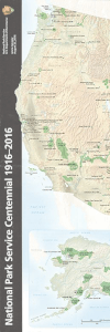 National Park Service
System Map
Price: $4
Where to order: U.S. Government Publishing Office
Where to see it: Online or at some visitor centers in the National Park Service System
Or: National Parks of the United States (National Geographic Destination Map)
North American road atlas
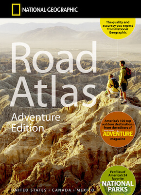
A North American road atlas provides the big picture road map on an extended national park road trip. I used daily and recommend the National Geographic Road Atlas: Adventure Edition. It contains information about most other resources described in this post. Nat Geo’s perspective uncovers interesting routes and places to see more simply and quickly than a 5″-wide navigation or travel app that may require a cellular signal that you don’t have.
This road atlas has maps of:
🇺🇸 Every U.S. state, usually 22″ across two pages. It shows major routes and places National Geographic recommends seeing in the spaces between the national parks.
🇨🇦 🇲🇽 Canada and Mexico. Both our neighbors have magnificent national parks, too. Online system maps are at ParksCanada and CONANP.
🏞️ A map similar to the National Park Service system map described above, but NPS’s is more clear and having it loose is convenient. This version of the NPS map is fine though.

Road atlas legend example
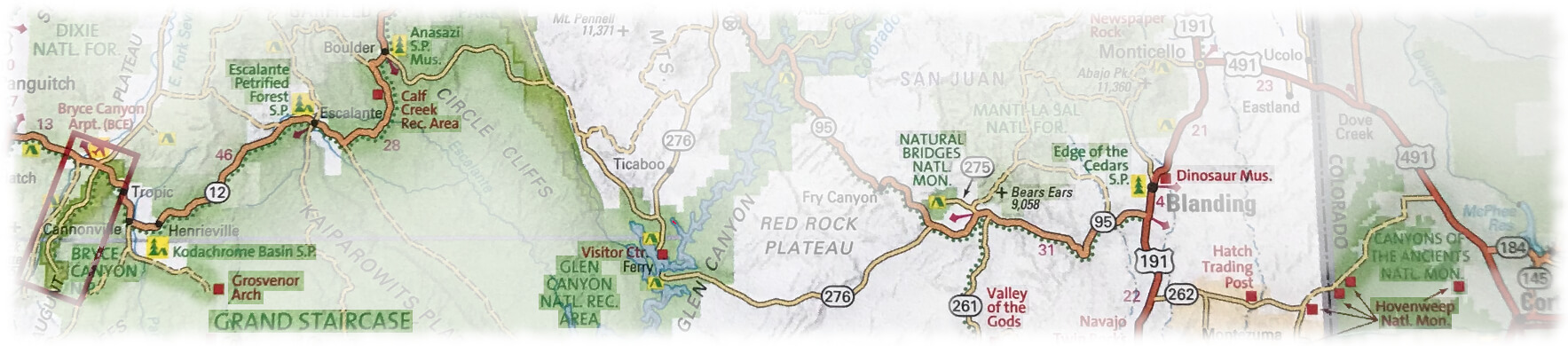
Park lands are shaded green. Besides the national parks, you can explore and camp in other kinds of federal public lands, such as those managed by the U.S. Forest Service, Bureau of Land Management (BLM), Bureau of Indian Affairs, and in the public land of state parks and state forests.
The map legend essentials are:
![]() Points of interest are in red text with a red square. These include places such as top attractions in parks, visitor centers, and museums.
Points of interest are in red text with a red square. These include places such as top attractions in parks, visitor centers, and museums.
![]() Scenic drives are traced with a green dotted line. When choosing a route, these are more interesting though often slower than the fast route your mapping service is likely to pick. I recommend a guidebook about scenic drives later in this article.
Scenic drives are traced with a green dotted line. When choosing a route, these are more interesting though often slower than the fast route your mapping service is likely to pick. I recommend a guidebook about scenic drives later in this article.

![]() Many public campgrounds are marked with a green tent icon and yellow highlighter. This is often enough information to find the campground if you don’t have a cellular signal or state road atlas. Highways have big brown signs with a tent triangle symbol just before the exit for the camp, then more arrows at turns that direct you to the campground. More about camping in the next two sections.
Many public campgrounds are marked with a green tent icon and yellow highlighter. This is often enough information to find the campground if you don’t have a cellular signal or state road atlas. Highways have big brown signs with a tent triangle symbol just before the exit for the camp, then more arrows at turns that direct you to the campground. More about camping in the next two sections.
At the start of your national park road trip, your enthusiasm will probably get you to your starting park fast.
When you recognize hurrying as the killjoy it is and emerge onto a slow road trip, this road atlas comes into its own. It suggests off-national-park-brand places nearby worth paying a visit. Humble-looking stops you never heard of on the map can turn out to offer some of the most memorable moments of your adventure.
You can get by on your national park odyssey with this road atlas alone, with help from visitor center brochures and the internet, but you will probably start needing more information.
 National Geographic Road Atlas: Adventure Edition
Where to order: Bookshop.org, Amazon, REI
Where to see one: Camping gear stores, bookstores, many park visitor centers
State campground guidebooks

Camping is the best way to see the national parks and other public lands. You sleep in the nature you came out to see, and it usually costs $0–35 a night. Some parks have no lodges if you even wanted one. It is mostly dry camping around the western national parks, which means no electricity or water at your campsite, though there may be a drinking water spigot somewhere in the camp.
Lots of camps are marked with a tent icon on the national road atlas. You can find campgrounds on the internet if you have a cellular signal or find a Wi-Fi hotspot. Offline GPS map navigation apps can find you camps.
A printed campground guidebook for a region gives you an organized survey of the favorite camps in an area. It groups campgrounds by subregion, describing the delights of the subregion and providing a review of each campground, along with practical information such as if it closes for the off-season.
If you want a particular camp and have internet access, online reviews can warn you of recent events, such as flood or fire. Your guidebook may say the camp is first come, first served, but online you may discover it has begun using a reservation system, often through recreation.gov. It can be hard to determine online that a camp has non-reservable campsites (first come, first served or a camping overflow lot) in addition to reservable ones.
Pick out a bunch along the way
In the high season and especially its weekends, campgrounds fill up, so you should have a list of possibilities. The competition for camps in national parks can be fierce, but in some it’s easy. National park camps are often spartan, but it is hard to beat hiking straight out of camp.
If you have a long drive to your next destination, use the national road atlas and/or a campground guidebook to spot lots of places where you can camp on the way there. Some regions have no public campgrounds.

If you get a strong positive reaction as you pass through an area, consider quitting your day’s driving plan and camping there. If you don’t, the place may haunt you, compelling you to return later to find out why it is calling you to come back. A hint that you may fall under its spell is if it’s on a scenic drive with campgrounds along it. Discovering a great place is why I recommend against having campground reservations unless the place plays a centerpiece to your grand adventure, such as might Slough Creek. Such campgrounds book up half a year in advance if you have those kinds of planning skills. The campground office can tell you how to try to get someone’s cancellation.
Sometimes you get dangerously sleepy while driving and camp wherever the next campground is, so it is good to know what camp is coming up, and not have a reservation three hours away. Or you could pull over and take a nap.
What’s in these campground guidebooks?
These campground guidebooks are usually for one state, though some are for a multi-state region or one section of a large state. They don’t include every campground.
They list mostly developed public campgrounds which charge a fee, have a host, potable water, and restrooms.
I had good experiences at private campgrounds, but campsites can be too close together and often cost more than at a public campground. These guidebooks list some private campgrounds that are in ideal locations.
Private campgrounds often have a partial (electricity & water) or full (+sewer) hookup at campsites. State park campgrounds are the most likely public land campground to offer hookups.
COVID-19 has closed camps at times, and some camps restrict the number of sites available to keep guests farther apart.
Did you say dispersed camping?
Instead of developed campgrounds, some people prefer dispersed camping (or primitive camping, or boondocking), which is free.
It is usually more private, fun, and beautiful than a developed campground, but there’s no security (host), water, or toilet. Wandering cattle may be surprised you are there and low about you to separated pockets of friends a mile away. The access road is often unimproved dirt and might become impassable after rain. Know the weather forecast. Dry, it might be so potholed you risk damaging your muffler, etc., so try to avoid the holes.
Dispersed camping is allowed with restrictions on certain public lands like in US Forest Service National Forests and Grasslands and Bureau of Land Management (BLM) land.
Sometimes you have no choice but dispersed camping because all of the public campgrounds are full, and you are a slow road tripper and don’t have a reservation.
If you have internet access, you can find free places to camp at freecampsites.net. Similar camping websites such as iOverlander, Campendium, and others offer camping apps that have offline capabilities.
The national road atlas conveys national forest boundaries, but BLM land gets more complicated. If you plan on mostly dispersed camping, you won’t need a campground guidebook, but you will need the next resource, the state road atlas, to find the color-coded demarcations of where the BLM land and National Forests are.
 State campground guidebooks
Where to order: Search book websites (Bookshop.org, Amazon) on “camping” plus the state name (e.g. camping Utah). Outdoor adventure publishers Moon and FalconGuides present fine offerings.
Where to see one: In camping gear stores in the state you want to camp in, and neighboring states.
State road atlases

You frequently will be unable to initiate turn-by-turn GPS navigation from an online navigation app such as Google Maps mapping service in remote areas during your national park road trip. Web mapping requires a data connection by either a line of sight to a cell tower or a Wi-Fi hotspot. You may get a signal if you walk or drive up a hill or rise, or get Wi-Fi at the park visitor center. Once you have initiated a trip session, your device has cached the map data, so you will make it to your destination even if it is through a cellular dead zone. Just don’t close your sessi😭n.
If you are exploring a backcountry that does not have widespread network coverage, you need an offline map. Your choices are either an offline GPS navigation program or paper maps.
Your GPS receiver can be an offline navigation app on your smartphone, a dedicated GPS unit, or your car’s onboard navigation system if you have one. The BLM offers maps that work with georeferenced map mobile applications, and links to the Avenza Maps Store. Your online navigation app may have some offline capabilities such as downloading maps, as does Google Maps mapping service. You have to get these maps before you lose contact with the Web.
Can I camp right here?
If you are exploring, a 20+″ wide paper map is easier to fathom than a 6″ smartphone screen.
If you are doing dispersed camping rather than using developed campgrounds, some offline map apps and all printed state atlases color code the boundaries of public lands, two kinds of which you are allowed to boondock on. So you can camp for free inside the boundary, but follow the rules.
In some states, there is a lot more BLM land than National Forest land. BLM land may be checkerboarded in with private land. If you have to guess, look for if anybody is camping there already, and hope he or she is right, or see if you can find an old-looking fire ring made of a circle of stones. If you picked out a spot on your own and you’re visible from the road, desperate camping cars may join you as the sun goes down.
There may be an unlocked, closed gate onto the public land, which is often to keep public land grazing livestock in. If you enter, leave the gate in the state you found it. The rancher may have put a “Private” sign on the gate if too many people have mistaken it.

I preferred the printed Benchmark state road atlas because I caught it labeling more public campgrounds than DeLorme’s atlas did for the same state. Benchmark distinguishes campgrounds by using a tent icon. DeLorme marks camps with the same square icon it uses for any other point of interest. These state road atlases show more public campgrounds than make it into the campground guidebooks.
But only if you need them
You may not need a printed state road atlas in flatter, populated areas with widespread cellular coverage, or if you are sticking to main roads and major attractions. If you are exploring the backcountry you may still need it to understand the geography and what there is to see.
You should wait till you get there to decide if you need a state road atlas. They are big. You might prefer locally created folding maps designed for tourism in a more limited area. Regional offices of tourism like Visit Utah may have the map you need for free in print and for download.
GPS turn-by-turn navigation tries to direct you off of a scenic drive and onto an interstate at every opportunity. You have to refer to your printed maps to know when to reject the service’s turning instructions. It continues navigating once it sees you “missed your turn.” There’s got to be a good navigation app out there that values pleasure drives over speed between endpoints, but I don’t know what it is.
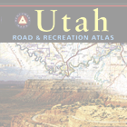 State road atlases
Where to order: REI, Amazon, publishers
Benchmark, DeLorme
Where to see one: You can find a DeLorme road atlas of your state in any state, but Benchmark is only in western states. State road atlases and folding state maps are sold in some convenience stores where cell service is unreliable, park visitor centers, camping gear stores, and bookstores within that state.
Nice to have guidebooks
After you get used to offline navigation with the guides above, you will know what the gaps are that will in turn lead to getting a box to keep the captain’s library from ending up everywhere in your vehicle. That’s entropy. I needed the following additional guidebooks.
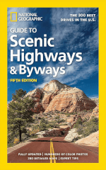
Scenic drives guidebook
The fortune cookie–length impulse to go on a very long road trip may deploy cover validation in a camouflaging excuse about a network of stationary goals, destinations: a purpose! with no mention of jonesing for the lines between points. So we utter something about going to see the national parks.
Perhaps the real goal is to wander in the desert. The national parks are credible-sounding beacons we know of ahead of time that are out there somewhere and are supposed to be good.
Some drives are more destinations in themselves than others, such as Historic Route 66.
States and federal public land agencies mentioned throughout this blog post, in conjunction with the Federal Highway Administration, have designated hundreds of Scenic Byways. Some of the national routes qualify for multiple reasons and become a step higher, All-American Roads.
Lots of national parks are on scenic byways, so you’re going on them. Some sections of interstates are scenic byways.
The tedium is the message
When traveling a long distance between national parks, you balance your enthusiasm to bypass everything and get there now by going 60+mph on whatever the fastest route is, against slowing down and taking a two-lane through America’s heartland. You may slow down so much you stop and camp for a closer look.
The national road atlas described above marks many of these scenic drives with a green dotted line along the route: ![]()
I used and recommend the National Geographic Scenic Highways & Byways guidebook. Other publishers offer similar guides, some in the cumbersome but immersive, visual field–filling coffee table format if you are at home envisioning legs of your odyssey.
Some regions call out touring topics such as history and culture. If you search the web on such a topic followed by the word “Trail” or “Highway,” you may find a dream route plotted by historians of the subject. For example, exploring the southeast might suggest the Civil War Trails, the Civil Rights Trail, or the Blues Highway. There are touring books on such topics if you are that committed. On the road, you may pass a signpost that says you are on an intriguing-sounding trail or are at one of its stops. In camp offices and visitor centers, eyeball the tiny to immense brochure racks for these trails, which contain a map.
You may deliberately head for or a brochure cover may tip you off that you are near the hometown of a famous person who made an imprint on you. Inside the brochure is a map with the addresses of her childhood home, church, and high school. Walk her old beat and imagine she’s you haunting the place.
You may find online or in print touring routes for the connoisseur of such things as mid-century diners and roadside attractions.
Mandatory offline navigation skill disclaimer
You should have a printed state road atlas or folding local road map if taking one of these routes somewhere with unreliable cell service or have offline-capable GPS navigation.
GPS navigation is antithetical to scenic driving unless there is only one way there. GPS picks the shortest path; scenic drives are the æsthetically widest path. You can get turn-by-turn navigation to assist if you add a node for each road turn until you plot out the route, but that may be technology for technology’s sake.
When starting your adventure, you’ll probably blast through on an interstate highway to get to your starting point. Same when you’re fleeing the fall’s first ten-degree cold front, or going in for the start of the shoulder season after the first good thaw in the spring.
Road trip guidebooks select and connect scenic byways if you’d like ideas for a starting route. You have to respond to conditions such as bad weather and fires, so you may switch road trips mid-road.

 National Geographic Scenic Highways & Byways
Where to order: Bookshop.org, Amazon
Where to see one: Bookstores’ US travel section, travel bookstores, some park visitor centers
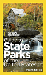
State parks guidebook
As grand as is the premise of a national park road trip, long, boring interstate drives, and at last, seeing famous sites in a large selfie-whipped crowd is at times as high stress and competitive as a job. They’ll yell at you to get out of their picture then smile for it.
There are a lot more kinds of public lands to explore when weary of the ways of man taking a selfie in a national park. Every state has its own public land in the form of state parks. They can be as magnificent as national parks. Many state parks pre-date national parks, so NPS was too late to snap them up as theirs. Redwood National Park in 1968 filled in the spaces between three state parks from the 1920s to make it like one large park.
State park campgrounds are usually beautiful and spacious, with showers, all rare in a national park campground. They usually cost more.
State parks next to national parks hold their own. When farther away from national park clusters, a state park campground makes a lovely place to stop and camp for the night if you are in a hurry. If you aren’t, the park is always a treat.
The national road atlas described above has a special icon for a state park campground: ![]()
There are ten thousand state parks. The National Geographic Guide to State Parks of the United States showcases a handful of the finest state parks in each state, what is so great about each, and if there’s a campground. At the end of each state’s section is a longer list of more great state parks, some of which you may think are better than Nat Geo’s top picks. All state parks are great.
 National Geographic Guide to State Parks
Where to order: Bookshop.org, Amazon
Where to see one: Travel bookstores, some park visitor centers


Thor’s Hammer in Bryce Canyon, Utah
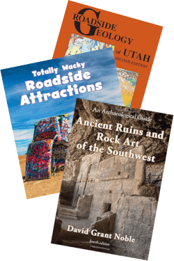
Guidebooks about your interests
All national parks give you a visitor brochure and a seasonal gazette, which are online with lots of other park information at the Find Your Park and National Park Service websites. These brochures showcase the many aspects of the park that together led to that land parcel’s apotheosis to national park status.
Oh, play that thing! ▶


Owachomo Bridge in Natural Bridges, Utah
Some of these aspects ignite your interest with enough fervor to become a separate voice in the fugue that is your road trip of a lifetime adventure. Places where you can explore these interests often extend over a much greater area than that enclosed by national parks.
Eventually, you may look for a map-based guidebook about your new favorite subject. Some interests may not have whole books about them, and you find out about piecemeal, such as online, from printouts and asking questions at visitor centers, from camp neighbors, or in offline apps created by people who love the same topic.
A frequent interest is in modes of moving through terrain—how to and accessing entry points to favorite routes. Some examples are hiking, mountain biking, rock climbing, and kayaking. This may be your only exercise as long as it isn’t motorized. There’s campground laps with a can of bear spray in one hand, but she can still get you from behind.
A complementary interest is in rays of illumination onto phenomena you encounter. Examples are animals and plant ecosystems, fossils, geology, dark sky stargazing, Native American culture, history, and remote art installations. Maybe start with visitor center booklets as needed and move on to a guidebook if your condition worsens. Books with color images get heavy and bulky.
Your interests coalesce, such as into a hike in which you scramble past dinosaur tracks that puzzlingly go vertically up a wall to try to find the petroglyphs in the cliffs, careful to avoid getting stuck by cacti you try to identify, someplace far from a national park and a hospital.
Beginner’s mind
If there is a map-based guidebook about your new interest, it may overwhelm you with the impulse to see everything mentioned in it in a million square mile blanket. You get a better handle on the book if you use it as a directory, where you can go bottom-up and look up what is nearby, or top-down and look up where you could go for what some call the finest or most fundamental examples of what it is that interests you.
You can wait till you get to your adventure’s starting point to discover what interests you about the area besides its national parks. If you want a preview of what topics obsess visitors, some of the top ones are addressed on tourism websites at the nested levels of government, such as VisitUtah.com and DiscoverMoab.com. Many national parks have an online bookstore such as Canyonlands Natural History Association which shows what subjects of interest patrons buy off their shelves. The Western National Parks Store shows subjects of interest across a lot of parks.

Pregnant bison at Nine Mile Canyon, Utah

Rock layers of the Grand Staircase of Utah and Arizona
Image: David Rumsey Map Collection, David Rumsey Map Center, Stanford Libraries

Blanche Russell rock house, Marble Canyon, AZ

Graphic: Copyright ©
2021 Meridian Line
Background: Angels Palace at Kodachrome Basin, Utah
Events in time such as famous multi-day music and arts festivals can require reservations and will put you on a schedule. The national road atlas marks towns with partial year live theater festivals, where you can often get rush tickets a few hours before the show.
 Touring guidebooks about your interests
Where to order: Preview topics at regional and park visitor sites, park bookstores
Where to see: Visitor center bookstores, camping gear stores
a highlighted southeast Utah route

Moab Man petroglyph
Conclusion
On your epic national park road trip, you and the Internet are in for a trial separation. You must have Internet-independent information with you to carry out your trip. You will sometimes have cellular service and you may find a Wi-Fi hotspot when you don’t.
Your information media choices are offline digital or print.
In this blog post, I argue that print is better suited for exploring geography than digital screens, and list which printed material is the most helpful.
Get your big picture of what’s out there by pondering maps of the National Park Service system and flesh out the spaces in between with a recreational national road atlas. Follow your inspiration, or let a lonesome highway billboard–informed whim take the wheel.
Pick up free printed guides at visitor centers, and chat up anyone in there. You will need detailed maps if you are exploring, information about campgrounds, and a happy relapse into a child’s wonder at your surroundings may make you grab for any explanation from natural and human history guidebooks.
The Internet is great help when you can reach it. It can fill in a lot more details, especially with up-to-the-minute information, and information that has not been published in books. You have to keep an eye on the weather forecast, but you can get that from broadcast radio if need be.
Use both paper and screens to find your way on your grand adventure. May you soon find them windshield wipers slappin time.
Image credits: Apple Compass app, David Rumsey Map Collection, Esri ArcGIS, Google Maps icon, The Meridian Line, National Geographic Partners, LLC, National Park Service, Tyler Nordgren. Google Maps is a trademark of Google LLC and material on this website is not endorsed by or affiliated with Google in any way. This is an independent website and has not been authorized, sponsored, or otherwise approved by Apple Inc.